|
|
 |
 Coastal Information System (C.I.S.)
|
The Coastal Information System CIS is a hydrodynamic atlas for the Arabian
Gulf. It contains of wave data, tidal data and Wind data.
|
Wave Data
The wave data was hindcasted using wind data obtained from the European Center for Medium Range Weather ECMWF.
The KISR WAM model was used for that purpose. The data covers the years 1979 till 2019 and is available
on a 0.1 degree grid for the Arabian Gulf as shown in Fig. 1. The data includes the significant wave height,
the mean wave period for the wave spectra and the mean wave direction.
|
The data covers:
- Area limits are
Longitude 47 deg 24 min to longitude of 56 deg 48 min
Latitude 23 deg 48 min to Latitude of 30 deg 30 min
- The available grid system (dx / dy) is 0.1 degree. Or (6 min)
- Time limits are
Years Jan. 1979 Till Aug. 2019
- Data Store in hourly system
The data includes the significant wave height, the mean wave period for the
wave spectra and the mean wave direction.
For wave data the following can be provided:
- Time series of wave height, period, and direction at any location.
- Wave rose as a plot and table at any location (monthly or yearly).
- Two dimensional wave data at a certain instant.
- Long term analysis of the wave data (100 year wave).
|
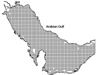
Grid used for the Arabian Gulf WAM model.
|
|
Hydrodynamic data
The tidal hydrodynamic data was generated using a tidal finite element hydrodynamic model for
the Arabian Gulf. The model boundary was applied at the Striate of Hormoz. The data
includes the tidal current and the water level over a non-uniform grid for the Arabian Gulf and the
Kuwaiti territorial waters.
|
The hydrodynamic data can be provided for:
- Time series of tidal water levels or currents at any location.
- Two dimensional hydrodynamic data at a certain instant.
- Tidal constituents at any location.
|
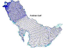
RMA Grid Covering the Arabian Gulf.
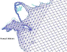
RMA Grid for the Northern Part of the Arabian Gulf
|
|
The Coastal Information System Database (C.I.S.) has been update
with new parameters that cover all Arabian Gulf waters for the following
MetOcean Parameters
- Sea water Temperature
- Air Temperature
- Evaporation Processes
Sea Parameters
- Gravity Wave Dissipation
- Northward Gravity Wave Surface stress
- Mean Sea Level Pressure
- Boundary Layer Heights
Data Limit Description
- Area covered from Strait of Hormuz to north Arabian Gulf stored in 2D
- Grids resolution 0.1 longitude/Latitude
- Time cover from Jan 1, 1979 To Aug, 2019
- Hourly stored
- Data can be extracted for 1D/2D
|
A New Digitial Bathymetry and Topography Elevation (DEM)DataBase for Arabian Gulf Water and Kuwait
New Satellite images were processed to obtain a new set of satellite-derived bathymetry and land elevation.
The data were from local digitized navigational charts and free data available from different sources.
Both data were used to create seamless elevation and bathymetry map of Arabian Gulf region and part
of the Indian Ocean / Arabian Sea.
The new data was created after interpolating (preserving original data values), resampling, clipping and
other post processing of six original data as shown below.
- Satellite Derived Bathymetry for shallow water South of Kuwait Bay, 10m grid
- CM93 chart data (contour lines and points in various resolution)
- GEBCO bathymetry, 30 sec grid
- Stereo Surface Model for Kuwait coastal area, 5m grid
- SRTM surface elevation data, 90m grid
- Coastline from spring 2016 (based on 10m satellite data)
A new Inerface was developed to Extract 1D/2D bathymetry and topography data
for Arabian Gulf and Kuwait water [ KGMap interface ] for Grid Size setup:
- Region 1 grid Size 1215m cover Arabian Gulf water and Gulf of Oman.
- Region 2 Grid size 405m cover Arabian Gulf Waters
- Region 3 Grid size 135m cover GCC Contury terrtorial waters
- Region 4 Grid size 45m Kuwait waters
- Region 5 Grid size 15m Kuwait waters
- Region 6 Grid size 5m Kuwait waters
|
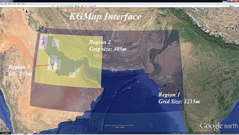
Multiple grids system for Arabian Gulf and Gulf Of Oman.
|
Four other grids were setup for the Kuwaiti territorial waters that can be used to provide more detailed data
at different locations in Kuwait.
|
Data Request Cost
The cost of the data explained above is as provided in the table below
|
Cost of Numerical Data Table
| Data |
Cost (K.D.) per Location |
Description |
| Hourly time series for wind data and Wind rose at a single location |
100/year or 400/five years |
Includes Wind Ux and Vy at 10m above Sea surface cover all Arabian Gulf from 1979
to 2018. |
| Extreme wave conditions (50 and 100 years) |
100 |
Based on 39 years of data. |
| Extreme wind conditions (50 and 100 year) |
100 |
Based on 39 years of data. |
| Hourly time series for wave data and Wave rose at a single location |
100/year or 400/five years |
Includes wave height, period and direction for 39 years (1979-2018), Cover
all Arabian Gulf waters. |
|
Wave Scater Digram Analysis and Plot 3D |
100 |
based on Wave height/Direction/Period for 39 year (1979-2018) cover all Arabian
Gulf waters |
| Hourly time series for hydrodynamic data. |
100/year |
Includes velocity magnitude and direction and water level. |
| Hourly water level data. |
50/year |
Form 1970 till 2037. |
| Tidal constituents 100 |
100 |
Amplitude and phase for 22 constituents. |
|
1D/2D bathymetry and topography data for Arabian Gulf and Kuwait water
|
Cost As pre-Request |
Highly accurate bathymerty data for Arabian Gulf Waters
|
|
Measured Data
For measured wave hourly time series (wave height, period and direction) the cost is
500K.D. per year.
|
The data can be purchased from KUWAIT INSTITUTE FOR SCIENTIFIC RESEARCH.
Time store Limit for Bouy Data 1993 to 1996 At Al-Fantas Coast.
Time Store Limot for Towers Data 1994 to 1997 at South of Auha Island.
To obtain the above data please provide details of your request then submit to the following Emails:
|
|
|
 |